Research

I have been studying crustal deformation based on geodetic observation such as GNSS and leveling, data analysis, and numerical modeling. My research objectives are to understand the crustal deformation over various spatio-temporal scales in a comprehensive manner with a special focus on various phenomena associated with large earthquakes at subduction zones as well as inland active faults, and also volcanic processes. I also aim to make a better forecast of future large earthquakes.
Recent technological advances in space geodesy has enabled us to monitor crustal deformation with a sub-centimeter level accuracy in real-time. By making use of such technologies, we can study physical processes during quiet preparation periods between large earthquakes and volcanic eruptions.
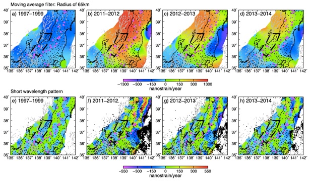
Nagoya is located close to the Nankai Trough, a famous plate subduction zone along the southwest Japan, and a lot of inland active faults. I have been conducting dense GNSS observation around active fault zones in central Japan to better understanding inland deformation processes. One of recent important findings is that tectonic loading process of inland faults is not driven by interaction at plate boundaries, but by tectonic stress accumulated in the inland crust. As a result, such loading process is persistent regardless of major plate boundary processes such as the 2011 Tohoku-oki earthquake.
I also have overseas collaborations with research groups in Spain, Colombia, Vietnam, and other countries.
If you are interested in collaborating or studying with me, please feel free to contact me.
Current Research Projects
-
✦ Inelastic deformation mapping for the island arc crust of East Japan (JSPS, Grant-in-Aid for Scientific Research (B), PI: Takeshi SAGIYA, 2018-2021)
-
✦ Study on plastic crustal deformation associated with stress history (JSPS, Grant-in-Aid for Scientific Research (C), PI: Yukitoshi FUKAHATA, 2019-2021)
-
✦ Evaluation of earthquake-tsunami potential along the Caribbean coast region of Colombia (JSPS, Bilateral Joint Research Project, 2021-2022)
-
✦ Intensified investigation and observation of the Byobuyama-Enasan Fault Zone and the Sanageyama Fault Zone (MEXT, PI: Yasuhiro SUZUKI, 2020-2022)
-
✦ GPS observation and data analysis around the Nagaoka Basin Western Boundary Fault (Collaborative Research with the Association for the Development of Earthquake Prediction, PI: Takeshi SAGIYA, 2010-2021)
-
✦ Geodetic surveillance on volcanoes in Canary islands (Collaborative Research with INVOLCAN)
Fault model of the 1944 Tonankai and 1946 Nankai Earthquakes
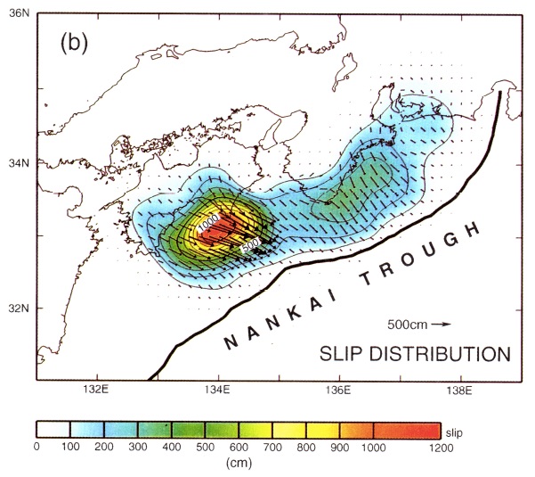
We analyzed conventional triangulation angle change as well as leveling data to estimate coseismic fault slip distribution of the 1944 and the 1946 Nankai earthquake, the last megathrust event along the Nankai Trough subduction zone. The next megathrust event is expected within this century and knowledge about previous earthquakes are very important for hazard preparedness (Sagiya and Thatcher, 1999).
Interplate coupling at subduction zones based on geodetic data inversion
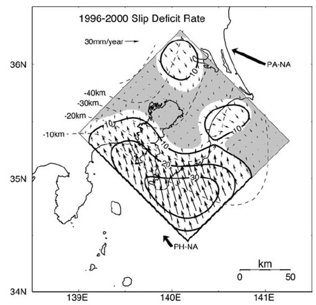
I studied interplate coupling at subduction zones, such as the Tokai and South Kanto area in Japan, and Nazca subduction zone in Colombia, based on geodetic data.These results provide us with valuable information about seismic potential of future interplate earthquakes (Sagiya, 2004).
The 1996 Boso slow slip event
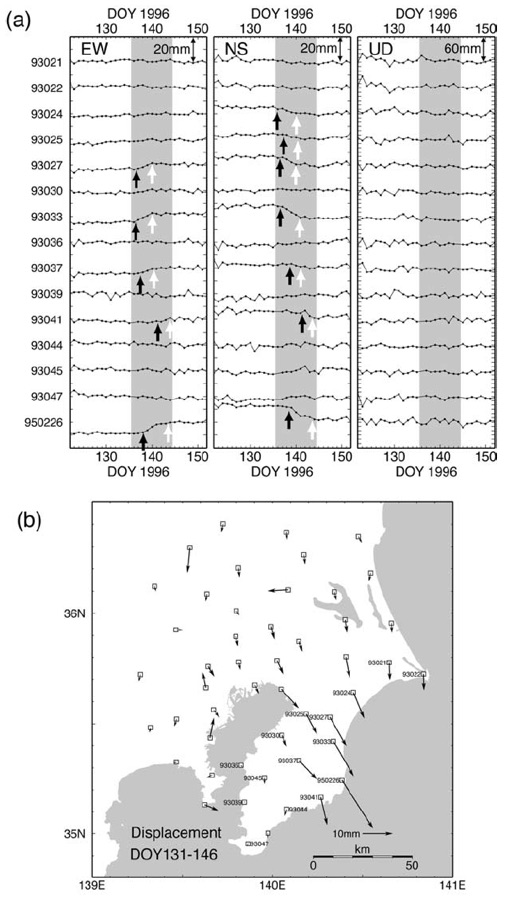
The 1996 Boso slow slip event was the first example of slow slip events detected by continuous GPS observation. Very small but coherent displacement signals were identified from GPS daily coordinates (Sagiya, 2004).
Paradoxical vertical crustal movement in NE Japan
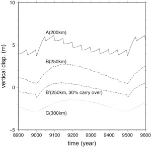
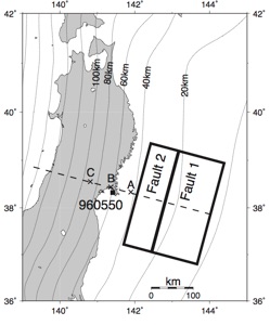
Temporal change of vertical crustal movements around the Pacific coast of the Tohoku district based on a simplified model of the plate subduction (Sagiya, 2015). The shallow fault (Fault 1) has a recurrence interval of 500 years while the deep fault (Fault 2) ruptures every 50 years. Viscoelastic relaxation causes time-dependent variation of the motion as a possible explanation for the interseismic as well as coseismic subsidence along the Pacific coast region. The model also predicts the uplift will continue for 1 or 2 centuries after the giant earthquake.
Identification of inland strain localization
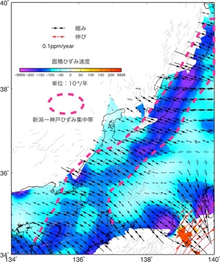
Strain rate distribution revealed by GPS observation. The Strain concentration zone (Niigata-Kobe Tectonic Zone (Sagiya et al. 2000) is delineated with red dashed lines.
Dense GPS observation around active faults
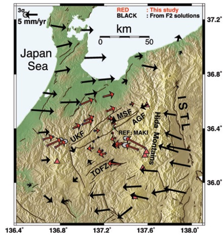
We have been conducting dense GPS observations around several active faults in central Japan, such as the Atotsugawa fault, the Atera fault, and the Itoigawa-Shizuoka-Tectonic Line. Through such observations we identified localized strain consistent with long-term deformation of each fault. The observation indicates that localized deformation below those faults in the lower crust is ongoing and loading the upper crustal faults (Ohzono et al., 2012).
Persistency of inland deformation
Modeling of lower crustal deformation
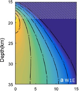
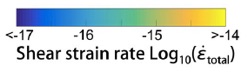
Numerical simulation result for lower crustal deformation shows strain localization just below an inland strike-slip fault. Under a slow (1mm/yr) slip rate condition, shear as well as frictional heating effect is negligible. But nonlinear rheology of anorthite contributes to the strain localization (Zhang and Sagiya, 2017).
Copyright @2019, 2020 Takeshi Sagiya All Rights Reserved
