パラメータ名
Parameter name
|
意味
Meaning
|
可能なパラメータ値
Allowed parameter values
|
デフォルト値
Default value
|
| input_file_format |
入力ファイルの形式。
The input file format.
|
- 3d
ymaeda_opentoolsの2次元・3次元データファイル形式
(独自のファイル形式参照)
で書かれた\((x,y)\)ごとの標高データ。
\((x,y)\)および標高は[m]単位で与える。
The data of altitude for each \((x,y)\)
given in a 2-D and 3-D data file format of ymaeda_opentools
(see special file formats).
Use the [m] unit for \((x,y)\) and the altitudes.
- xy
第1列を直交座標系における\(x\)座標[m]、第2列を\(y\)座標[m]、
第3列をその\((x,y)\)における地表面の標高[m]とするデータ。
列の区切りにはタブを使用する。
The data given by
the \(x\)-coordinate [m] of a cartesian coordinate system
in the 1st column,
\(y\)-coordinate [m] in the 2nd column,
and the ground surface altitude [m] at that \((x,y)\)
in the 3rd column.
Use tabs to separate the columns.
- latlon
第1列を緯度、第2列を経度、
第3列をその水平位置における地表面の標高[m]とするデータ。
列の区切りにはタブを使用する。
緯度・経度は度単位の実数または「度:分:秒」形式の文字列とする。
The data given by
the latitude in the 1st column,
the longitude in the 2nd column,
and the ground surface altitude [m] at that horizontal location
in the 3rd column.
Use tabs to separate the columns.
The latitude and longitude can be specified by
a real number in the degree unit or
a string in “degree:minute:second” format.
|
3d |
| refN |
緯度経度を直交座標に変換するための基準点の緯度。
The latitude of the reference point
for the conversion from latitudes and longitudes
to cartesian coordinates.
|
度単位の実数または「度:分:秒」形式の文字列。
-90°以上90°以下でなければならない。
A real number in the degree unit
or a string in “degree:minute:second” format.
The value must be greater than or equal to -90 degrees
and less than or equal to 90 degrees.
|
input_file_format=latlonの場合は省略不可。
それ以外の場合は使用されない。
Cannot be omitted if input_file_format=latlon,
not used otherwise.
|
| refE |
緯度経度を直交座標に変換するための基準点の経度。
The longitude of the reference point
for the conversion from latitudes and longitudes
to cartesian coordinates.
|
度単位の実数または「度:分:秒」形式の文字列。
-180°以上180°以下でなければならない。
A real number in the degree unit
or a string in “degree:minute:second” format.
The value must be greater than or equal to -180 degrees
and less than or equal to 180 degrees.
|
input_file_format=latlonの場合は省略不可。
それ以外の場合は使用されない。
Cannot be omitted if input_file_format=latlon,
not used otherwise.
|
| xmin |
採用するデータの\(x\)座標の下限\(x_{min}\)[m]。
\(x<x_{min}\)の地点の標高データは使用しない。
The lower limit, \(x_{min}\) [m],
of the \(x\)-coordinate of the data used.
The altitude data at locations with \(x<x_{min}\) are not used.
|
実数。
A real number.
|
省略時は下限無しとなる。
The lower bound is not introduced when this parameter is omitted.
|
| xmax |
採用するデータの\(x\)座標の上限\(x_{max}\)[m]。
\(x>x_{max}\)の地点の標高データは使用しない。
The upper limit, \(x_{max}\) [m],
of the \(x\)-coordinate of the data used.
The altitude data at locations with \(x>x_{max}\) are not used.
|
\(x_{min}\)よりも大きな実数。
A real number greater than \(x_{min}\).
|
省略時は上限無しとなる。
The upper bound is not introduced when this parameter is omitted.
|
| ymin |
採用するデータの\(y\)座標の下限\(y_{min}\)[m]。
\(y<y_{min}\)の地点の標高データは使用しない。
The lower limit, \(y_{min}\) [m],
of the \(y\)-coordinate of the data used.
The altitude data at locations with \(y<y_{min}\) are not used.
|
実数。
A real number.
|
省略時は下限無しとなる。
The lower bound is not introduced when this parameter is omitted.
|
| ymax |
採用するデータの\(y\)座標の上限\(y_{max}\)[m]。
\(y>y_{max}\)の地点の標高データは使用しない。
The upper limit, \(y_{max}\) [m],
of the \(y\)-coordinate of the data used.
The altitude data at locations with \(y>y_{max}\) are not used.
|
\(y_{min}\)よりも大きな実数。
A real number greater than \(y_{min}\).
|
省略時は上限無しとなる。
The upper bound is not introduced when this parameter is omitted.
|
| Nmin |
採用するデータの緯度の下限。
この緯度よりも南にある標高データは使用しない。
なお、この設定はinput_file_format=latlonの場合のみ有効である。
The lower limit of the latitude of the data used.
The altitude data at locations more south than this latitude
are not used;
this setting is valid only when input_file_format=latlon.
|
度単位の実数または「度:分:秒」形式の文字列。
-90°以上90°以下でなければならない。
A real number in the degree unit
or a string in “degree:minute:second” format.
The value must be greater than or equal to -90 degrees
and less than or equal to 90 degrees.
|
省略時は下限無しとなる。
The lower bound is not introduced when this parameter is omitted.
|
| Nmax |
採用するデータの緯度の上限。
この緯度よりも北にある標高データは使用しない。
なお、この設定はinput_file_format=latlonの場合のみ有効である。
The upper limit of the latitude of the data used.
The altitude data at locations more north than this latitude
are not used;
this setting is valid only when input_file_format=latlon.
|
度単位の実数または「度:分:秒」形式の文字列。
-90°以上90°以下、
かつパラメータNminの値よりも大きくなければならない。
A real number in the degree unit
or a string in “degree:minute:second” format.
The value must be greater than or equal to -90 degrees
and less than or equal to 90 degrees,
and greater than the value of parameter Nmin.
|
省略時は上限無しとなる。
The upper bound is not introduced when this parameter is omitted.
|
| Emin |
採用するデータの経度の下限。
この緯度よりも西にある標高データは使用しない。
なお、この設定はinput_file_format=latlonの場合のみ有効である。
The lower limit of the longitude of the data used.
The altitude data at locations more west than this longitude
are not used;
this setting is valid only when input_file_format=latlon.
|
度単位の実数または「度:分:秒」形式の文字列。
-180°以上180°以下でなければならない。
A real number in the degree unit
or a string in “degree:minute:second” format.
The value must be greater than or equal to -180 degrees
and less than or equal to 180 degrees.
|
省略時は下限無しとなる。
The lower bound is not introduced when this parameter is omitted.
|
| Emax |
採用するデータの経度の上限。
この緯度よりも東にある標高データは使用しない。
なお、この設定はinput_file_format=latlonの場合のみ有効である。
The upper limit of the longitude of the data used.
The altitude data at locations more east than this longitude
are not used;
this setting is valid only when input_file_format=latlon.
|
度単位の実数または「度:分:秒」形式の文字列。
-180°以上180°以下、
かつパラメータEminの値よりも大きくなければならない。
A real number in the degree unit
or a string in “degree:minute:second” format.
The value must be greater than or equal to -180 degrees
and less than or equal to 180 degrees,
and greater than the value of parameter Emin.
|
省略時は上限無しとなる。
The upper bound is not introduced when this parameter is omitted.
|
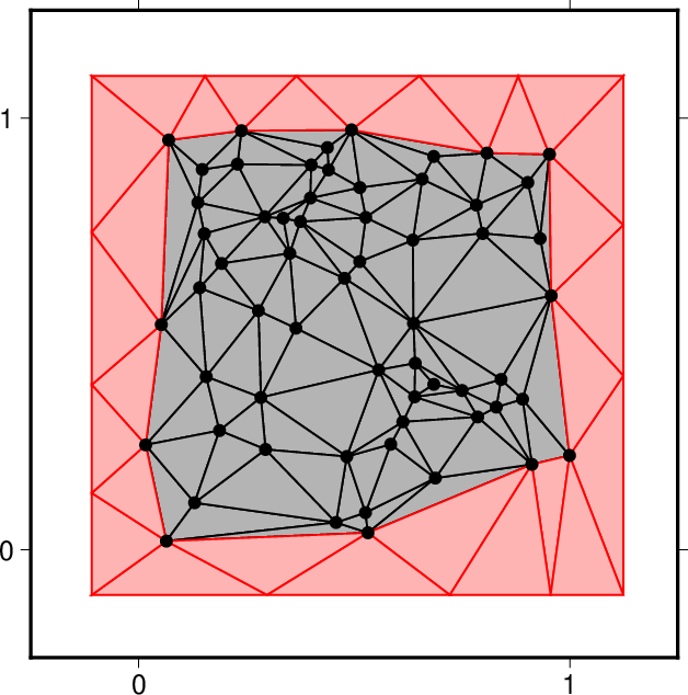
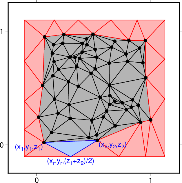
| add_straight_boundary |
\(x\), \(y\)軸に平行な外周を追加するか否かの選択。
このプログラムでは標高定義点の分布について
いかなる仮定も置いていないので一般に外周はまっすぐではない。
そこで、人工的な外周を追加して外周をまっすぐにするか否かを
このパラメータで選択する。
A choice of whether to add outer boundaries
parallel to \(x\)- or \(y\)-axes or not.
Note that this program introduces no assumption for
the spatial distribution of altitude definition points;
therefore, the outer boundary is not necessarily straight.
This parameter enables adding an artificial boundary
to make the boundary straight.
|
- yes
外周を追加する(図1)。
Add outer boundaries (Fig. 1).
- no
外周を追加しない。
この場合、たとえ標高定義点の分布が
\(x\), \(y\)軸に平行な長方形格子状であったとしても
三角形要素がカバーする領域が長方形になるとは限らない点に留意。
Do not add outer boundaries.
Note that in this case,
the region covered by the trianglar elements may not be rectangular
even if the altitude definition points are distributed
on rectangular grid nodes parallel to the \(x\)- and \(y\)-axes.
|
no |
| bottom |
作成する固体領域の下限の標高[m]。
有限要素法を用いたシミュレーション等、地表面そのものではなく
地表面を上面とする有限サイズの3次元固体領域を構築したい場合に
このオプションを使用する。
なお、このオプションを使用するには
add_straight_boundary=yesとする必要がある。
The lower limit altitude [m] of the solid volume to create.
Use this option to create a finite-size 3-D solid volume
with the ground surface at the upper bound,
for example for a numerical simulation with a finite element method,
instead of simply creating the geometry of the ground surface.
Note that this option is available only when
add_straight_boundary=yes.
|
標高を表す実数。使用するデータの全ての標高よりも低くなくてはならない。
A real number that represents an altitude,
which must be lower than the altitudes of all data used.
|
省略時は有限サイズの3次元固体領域を作成しない。
The finite-size 3-D solid volume is not constructed
when this parameter is omitted.
|